The Importance of Accurate Elevation Data
Obtaining node elevation data for input into a water distribution model can be an expensive, time-consuming process. In some cases, very accurate elevation data may be critical to the model’s utility; in other cases it can represent a significant resource expenditure. In order to decide on the appropriate level of quality of elevation data to be gathered, it is important to understand how a model uses this data.
Elevation data for nodes is not directly used in solving the network equations in hydraulic models. Instead, the models solve for hydraulic grade line (HGL). Once the HGL is calculated and the numerical solution process is essentially completed, the elevations are then used to determine pressure using the following relationship:
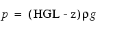
| p | = | pressure (lb./ft. 2 , N/m 2 ) | |
|---|---|---|---|
| HGL | = | hydraulic grade line (ft., m) | |
| z | = | node elevation (ft., m) | |
| ρ | = | density of water (slugs/ft. 3 , kg/m 3 ) | |
| g | = | gravitational acceleration (ft./sec. 2 , m/sec. 2 ) |
If the modeler is only interested in calculating flows, velocities, and HGL values, then elevation need not be specified. In this case, the pressures at the nodes will be computed assuming an elevation of zero, thus resulting in pressures relative to a zero elevation.
If the modeler specifies pump controls or pressure valve settings in pressure units, then the model needs to compute pressures relative to the elevation of the nodes being tested. In this case, the elevation at the control node or valve would need to be specified (or else the model will assume zero elevation). Therefore, an accurate elevation value is required at each key node where pressure is of importance.